


PROPERTY SEARCH

Tracking natural disasters in Spain: How to view a real-time satellite map
Why real-time satellite imagery has become essential in helping Spain face fires, floods and heatwaves in real time
by Kateryna Sergieieva
Watching the recent news from Valencia has been absolutely distressing. It’s one thing to discuss climate change in the abstract, but seeing a year’s worth of rain destroy a community in just eight hours is a terrifying reality check.
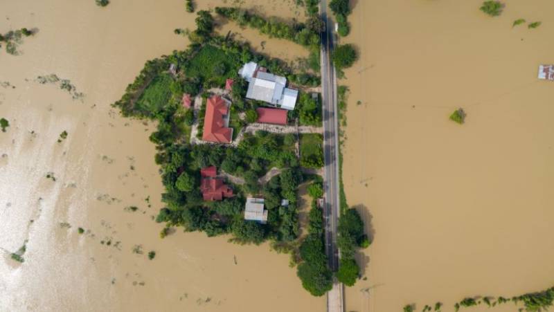
The way the Magro and Turia rivers ripped through those towns is nearly impossible to process just by standing on the street. It is overwhelming. That is why, in moments of absolute chaos, I find myself turning to current satellite imagery to make sense of it all.
Of course, rescue teams operate based on ground reports, but in recent years another major factor has come into play: satellite imagery. The satellite view of the landscape offers a perspective that ground inspections can’t.
Why satellite monitoring matters
It is incredibly frustrating and dangerous when a storm hits, and ground sensors go dark because they have been washed away or power lines are down. In moments of crisis, traditional monitoring often fails exactly when we need it most. That is where the value of current satellite imagery lies; specialists can view a real-time satellite map without caring about a flooded road or a burnt-out transmission tower:
- Wildfire tracking: We can spot heat signatures and hotspots instantly, predicting exactly where a fire line is moving before ground crews can even see the smoke.
- Flood analysis: It allows us to watch river levels swell in real-time and identify which neighbourhoods are at imminent risk of inundation.
- Storm surveillance: We can track the formation and trajectory of massive systems like the DANA before they make landfall.
- Post-disaster management: Destruction can be assessed safely from a distance without risking the rescue team's lives in unstable zones.
Natural disasters commonly monitored in Spain
Living in Spain these days feels like being caught in a tug-of-war between fire and water. It is unnerving how quickly the weather here can shift from a sunny day to a life-threatening emergency. Satellite technology has become our honest, unblinking eye in the sky, helping us track the three main threats that keep many of us up at night.
- Wildfires: Every summer, the anxiety spikes. Our dry pine forests are basically kindling, and once a fire starts, it moves faster than you can run. By accessing a current satellite view of Earth, emergency crews can spot heat anomalies in remote mountains long before anyone on the ground even smells the smoke. It gives them a fighting chance to react before it is too late.
- Floods: We cannot talk about disasters without pausing for Valencia. The recent storm was absolutely devastating and, frankly, hard to process. It wasn't just rain; it was a year’s worth of water dumping down in eight hours, turning the Magro and Turia rivers into monsters. Looking at the satellite maps of the aftermath is heartbreaking, you can clearly see the brown stains of mud burying entire neighbourhoods. It is a stark, painful reminder of nature's power.
- Heatwaves and drought: While less explosive than a storm, the "silent killer" here is the heat. Farmers in the south are watching their land turn to dust. Satellites allow us to track this slow-motion disaster by analysing soil moisture, confirming the harsh reality that the land is getting thirstier by the year.
How to view a real-time satellite map
It wasn't long ago that "eyes in the sky" were a luxury reserved for governments and scientists. Thankfully, that era is over. Today, anyone with a smartphone can access a live satellite view of Earth, and honestly, I find this accessibility incredibly empowering. These modern platforms are surprisingly intuitive and offer much more than just a pretty picture:
- Weather dynamics: In the up-to-date platforms, it is easy to see exactly where rain is falling, just by changing the layers inside the app.
- Hazard detection: Special filters clearly highlight active fire hotspots and smoke plumes.
- Local focus: The ability to zoom right into specific Spanish regions to check on local conditions.
Benefits for public safety and awareness
There is a massive difference between hearing a generic warning and actually seeing the danger with your own eyes. Personally, I believe having access to current satellite views completely changes how we react to crises. It stops us from sitting around helplessly waiting for the news and lets us take charge of our own safety. When the threat is visible, the denial fades away.
People can check a map from satellites and see with their eyes how real and urgent the risk is without any guesswork. Based on this information, families can cancel their trips or better prepare for changing weather, and rescue teams can plan their routes into zones where they are needed most.
A crucial eye on our changing world
Let’s face it, extreme weather in Spain is fast becoming part of daily life here. That is why satellite tech has stopped being just a cool tool for scientists and has become something we actually rely on. Being able to pull up a live, real-time satellite view on your phone gives you the control to make smart, split-second decisions. In a world changing this fast, staying glued to these maps isn't just about gathering data; it is about doing what it takes to ensure we are still standing when the storm passes.
Kateryna Sergieieva has a Ph.D. in information technologies and 15 years of experience in remote sensing. She is a scientist responsible for developing technologies for satellite monitoring and surface feature change detection. Kateryna is an author of over 60 scientific publications.


See more environmental news about Spain:
OR
Sign up for the Spanish News Today Editors Roundup Weekly Bulletin to get a comprehensive email with all the week’s news for Spain, Murcia, Alicante and Andalucía.
Get a sneak peek – here are a few of our recent Subscription Bulletins:
Discount Special Offer subscription:
36.95€ for 48 Editor’s Weekly News Roundup bulletins!
Please CLICK THE BUTTON to subscribe.